In 1798, more than forty years after his first campaign in the Ohio Country, George Washington recalled that “the burthen of obtaining the Grants for 200,000 acres of land under Governor Dinwiddie’s Proclamation of 1754” had largely fallen upon him. A newly acquired 1772 manuscript patent, commonly referred to as the Savage Grant, is one of the more substantial surviving records of that effort. The document preserves the names of men connected directly to Washington’s first military command. It also opens onto a larger story of his long struggle with western land administration and an imperial government that often proved slow and difficult in securing the rewards promised for military service.
That story began in February 1754, when Virginia lieutenant governor Robert Dinwiddie promised 200,000 acres of western land to officers and soldiers willing to serve in Virginia’s expedition to the Ohio Country. Among them was John Savage, commissioned a lieutenant on March 9, 1754. He served under Washington at Fort Necessity, was promoted to captain the following year, and went on to command a company in the Virginia Regiment. Washington’s Virginia force numbered about 293 officers and men and was reinforced by roughly 100 British regulars from South Carolina. In the fighting on July 3, his command suffered more than 100 casualties. The Savage Grant names sixty-one claimants connected to Washington’s 1754 Virginia Regiment. Many can be identified in surviving Fort Necessity rosters, including men recorded as killed or wounded during the campaign. These were the men, or their representatives, for whom the promised bounty lands were still due nearly two decades later.
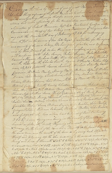
Land patent to John Savage and others for 28,627 acres in Fincastle County, Virginia, 1772 December 15. (section.)
The road to this patent stretched from Dinwiddie’s 1754 proclamation through nearly two decades of claims and surveys. On October 2, 1770, John Savage came to Mount Vernon to enter his claim to a share of the promised 200,000 acres. William Crawford subsequently surveyed the lands, including the 28,627-acre tract represented by this patent, and in 1772 the Virginia Council ordered it patented in the names of Savage and other veterans. Savage, whose service as a subaltern officer entitled him to 6,000 acres, received 3,428 acres in this first distribution. Four sergeants received 600 acres each, four corporals 500 acres each, and fifty-two private soldiers 400 acres each. Their claims totaled 28,628 acres—one acre more than the survey. Washington noted simply: “One acre short.”
Today, portions of the Savage Grant lie within four counties of West Virginia. The patent itself preserves that western landscape in the language of an eighteenth-century survey. Its long “metes-and-bounds” description begins at “a small Elm marked G.W.” and follows natural landmarks around the enormous tract. Read closely, the survey becomes almost a catalogue of the American landscape: elm, beech, black gum, sugar tree, hickory, sycamore, poplar, and oak mark the boundaries of the tract. Trees, creeks, ridges, and rocks gave legal shape to property on the western frontier before fences and modern maps.
Thomas G. Lannon
Library Director