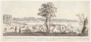
This watercolor of the loyalist camp on the St. Lawrence River was executed by James Peachey (d. 1797), one of the surveyors responsible for laying out the townships and farm lots for the loyalists who occupied the camp during the summer of 1784. It is one of the few sympathetic contemporary depictions of loyalist refugees. Its full title is Encampment of the Loyalists at Johnstown, a New Settlement, on the Banks of the River St. Lawrence in Canada, taken June 6th 1784.
In the last year of the Revolutionary War, displaced loyalists entered the province of Quebec in increasing numbers, seeking new homes. To meet this need, the governor general, General Sir Francis Haldimand, projected the establishment of twenty-one townships of 21,040 acres each to provide the newcomers with land. He instructed Samuel Holland, surveyor general of lands for the Province of Quebec and Northern District of North America, to survey the banks of the upper St. Lawrence River and Lake Ontario with the expectation that initial settlement would extend from the St. Lawrence upstream from Montreal to as far west as the Bay of Quinty on the northeast shore of the lake, with additional settlements in the vicinity of Niagara.
Holland reported that most of the region would make fine farms. “I am happy to find that there are in the Gift of the Crown,” Haldimand wrote to his superiors in Britain, “Lands of so good a soil and in a favourable Climate, sufficient not only to settle the Provincial Corps when disbanded, but all such Royalists as may come from the Southward with a view to find an Asylum from the Tyranny and Oppression of their Countrymen. I foresee great advantages from the settlement.”
Loyalist regiments in the vicinity of Montreal were disbanded in December 1783 and the refugees were gathered together at Sorel, where the army provided them with food and supplies until the river was free of ice and they could be moved by boat to a new camp on the St. Lawrence above Montreal. The loyalists were moved to Montreal in April and, after several weeks of chaotic preparations, departed Montreal in bateaux between June 3 and June 24, carrying the possessions as well as tools and seed provided by the government. The journey by boat took ten to twelve days.
The camp would become Johnstown—the future administrative center of what became known as Upper Canada—but in June 1784 it was a collection of tents and a few simple frame buildings to house the settlers until surveys were completed and lots assigned. Most of the settlers were veterans of the King’s Royal Regiment of New York. They moved out of the camp and on to their new farms as soon as the allotments were made. The last of the settlers were on their land by September.
The artist, James Peachey, was first employed as a survey draftsman under Samuel Holland from about 1773 to 1775. Holland’s surveys were incorporated into J. F. W. Des Barres’s The Atlantic Neptune (4 vols., London, 1777-1784) in which the maps are supplemented by topographical views similar to some of Peachey’s works. Peachey returned to British America by 1780, and in 1783 Holland instructed Peachey and his colleagues, René H.P. La Force and Louis Kotte, to explore the north shore of Lake Ontario to identify areas for settlement. Peachey spent several months conducting lot surveys before returning to Britain in November 1784.
Peachey’s view of the loyalist encampment was one of several detailed watercolors he executed, probably for publication as insets in a large-scale map of the St. Lawrence River that was never published. He also etched outlines of topographical views of Canada. Aquatints of some of his Canadian views were published in London in 1785 and 1786. He also provided the frontispiece for a primer for the use of Mohawk children and illustrations for a Mohawk language edition of the Book of Common Prayer.
Peachey may have sketched the scene in 1784 but not completed the watercolor until 1790 or after. This would account for the town name in the title. A town plan was drawn up for the site in 1788 and the town named Johnstown, after Sir William Johnson, in 1790. In 1792, John Graves Simcoe, the first lieutenant governor of Upper Canada, made Johnstown the administrative seat of the district. By the end of the decade, the town had a sawmill, a gristmill and a tavern in addition to a courthouse and jail. In 1807 Johnstown consisted of thirty-six houses.
Peachey returned to British America for a final time in 1788, having secured a commission as an ensign in the British army. He resumed his work as deputy surveyor under Holland and was later promoted to lieutenant and finally to captain in 1795, when he seems to have returned to Britain. He was definitely in Britain by early 1797, when his regiment was dispatched to the West Indies. Peachey died in Martinique, then occupied by the British, in late 1797.