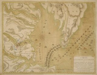
 This landmark French map is one of the most comprehensive of the Yorktown campaign and presents the actions, on land and at sea, that resulted in the decisive victory of the allied forces. Titled Carte de la Partie de la Virginie ou l’Armée Combinée de France & des États-Unis de l’Amérique a fait prisonnière l’Armée Anglaise comandée par Lord Cornwallis le 19 Octbre 1781 (Paris: Chez Esnauts et Rapilly, ca. 1782), the map is a prized addition to the Robert Charles Lawrence Fergusson Collection, acquired in November 2017.
While most American and British maps of the siege focus on the actions of the ground forces and ships in and around Yorktown and Gloucester, this French map pulls back to encompass the Chesapeake Bay region all the way up to the Potomac River. It emphasizes, in dramatic schematic form, the key role of the French navy in sealing off the entrance to the bay, trapping Cornwallis’s army on the Yorktown peninsula. Outside the blockade, the British fleet, defeated at the Battle of the Capes, is shown preparing to return to New York, with one of its badly damaged ships, the Terrible, scuttled and in flames. In one of his earliest communications with General Rochambeau, George Washington wrote that, “In any operation, and under all circumstances a decisive Naval superiority is to be considered as a fundamental principle, and the basis upon which every hope of success must ultimately depend.” This map illustrates the fulfillment—and proof—of that principle.
View the map in more detail on our Digital Library.
View More Maps in Our Collections