Below is an alphabetical listing of the cities, battle sites and geographic locations featured in Revolutionary Choices.
THE PLACES OF <em>REVOLUTIONARY CHOICES</em>
ALBANY, NEW YORK
During the war, ships would sail 150 miles up the Hudson River to Albany, New York, a premier trade hub where goods from upriver and from the surrounding farms were bought and shipped back down the river.
Boston, Massachusetts
New England’s largest city and most important port, Boston was the center of resistance to British taxes and other policies infringing on the colonists’ rights. The British sent troops to occupy the city in 1768 but were unable to subdue surrounding towns or disarm the colonists.
Charleston, south Carolina
Charleston served as the capital of South Carolina and the most important port city in the South. Charleston merchants sold rice and other foodstuffs in the West Indies and imported fabric, tools, and luxury goods for sale in the Carolinas and Georgia.
Derryfield, New Hampshire
Derryfield (now Mansfield) is situated along the Merrimack River, which flows through New Hampshire and parts of Massachusetts. The Merrimack Valley provided timber for shipbuilding and was home to a growing number of farms. A blockhouse fort, called Stark’s Fort, was built there in 1746.
Dover, Delaware
Dover’s situation relatively inland from other towns along the Delaware coast made it difficult for the British to attack.
Falmouth, Maine
Falmouth (today suburban Portland) was a small deep-water port in a protected harbor off Casco Bay on the coast of Maine, which was then part of Massachusetts. The people of Falmouth sent supplies to the Patriot army surrounding Boston.
Fort Niagara, New York
French-built Fort Niagara on Lake Ontario was captured by the British in the French and Indian War. It was the most important British fort on the Great Lakes and the center of British trade and diplomacy with the very powerful Iroquois Confederacy on the northern frontier.
Fort Pitt, Pennsylvania
During the French and Indian War, the British built Fort Pitt where two rivers join to form the Ohio River—today modern-day Pittsburgh. During the American Revolution, Fort Pitt’s location made it one of the most important points on the Western frontier.
Fort Stanwix, New York
Fort Stanwix protected important waterways throughout western New York. Abandoned prior to the war, the fort was reoccupied and rebuilt by Continental forces, who renamed it Fort Schuyler.
Fort Ticonderoga, New York
Fort Ticonderoga, armed with heavy cannon, was situated south of Lake Champlain. The fort commanded the water route between Canada and New York’s Hudson River Valley. Built in the 1750s by France, the British captured it during the French and Indian War.
Fort Western, Maine
Colonists built Fort Western at the northern limit of navigation on the Kennebec River, the most important river In Maine (then part of Massachusetts). The trading post served trappers and others who lived upriver, and eventually became Maine’s capital, Augusta, in 1820.
Hartford, Connecticut
Hartford was one of the most important inland towns in New England. Located in the broad and fertile valley of the Connecticut River, Hartford was a major market town for a rich farming region that supplied food to George Washington’s army.
Lancaster, Pennsylvania
Lancaster was an important market town west of Philadelphia. Surrounded by well-cultivated farms the area also included many iron furnaces, where cannonballs and cannon barrels could be manufactured. Lancaster also became a center for gun manufacturing.
Montreal, Canada
Montreal, located on the St. Lawrence River between Quebec and Lake Ontario, was a center of the fur trade with the indigenous tribes of the Great Lakes and western New York.
New York, New York
New York was the most important port along the North American coast, with a large natural harbor that drew in goods from the Hudson River Valley, Long Island, Connecticut, and New Jersey. Surrounded by a maze of waterways, it was difficult to defend from the large and powerful British Navy.
Newport, Rhode Island
Newport was one of the most important ports in New England; its protected harbor was the finest one between Boston and New York. Newport merchants traded fabrics, tools, food, and New England rum, and conducted extensive commerce in the West Indies.
Ninety Six, south Carolina
Ninety Six was a small trading village and fortified outpost at an important crossroads on the South Carolina frontier.
Philadelphia, Pennsylvania
Philadelphia was the largest city in British North America, serving as both a marketplace for the rich farming areas in Pennsylvania and a key manufacturing center. Located on the Delaware River, its central location was an ideal meeting place for representatives of the thirteen colonies.
Quebec, Canada
Quebec, a fortified city on the St. Lawrence River, connects the Great Lakes to the Atlantic Ocean. Much of the trade in furs and other goods from the Great Lakes needed to pass by Quebec, which made it a place of strategic importance to the British.
Savannah, Georgia
The largest town in Georgia, Savannah is located on the Savannah River about twenty miles from the Atlantic Ocean. Most of Georgia’s trade passed through Savannah, which exported deer and cow hide to Europe and rice and other food to the West Indies.
St. Augustine, Florida
St. Augustine contains a large stone fort built by the Spanish named Castillo de San Marcos. This town was the capital of the colony of East Florida, which the Spanish ceded to the British in exchange for Cuba and the Philippines after the French and Indian War. The town was a desired target for southern Patriots.
Staunton, Virginia
Staunton was an important frontier trading center for wheat and tobacco in Virginia’s Shenandoah Valley. The city facilitated the economic growth of the region during the American Revolution.
Tioga Point, New York
Tioga Point was the southern gateway to the Iroquois lands of western New York. Allied with the British, the Iroquois raided the frontier. Americans marched northwest to Tioga Point in 1779 and established a fort there to use as a base to attack the Iroquois.
West Point, New York
Located at a strategic bend in the Hudson River, a fort built at West Point could control movement up and down the river and protect crossings to the north, over which food and other supplies from New England traveled to reach George Washington’s army.
Williamsburg, Virginia
The state capital at the outbreak of war, Williamsburg is located on the peninsula between the James and York Rivers. In 1775 Lord Dunmore seized Williamsburg’s gunpowder stores, a pivotal moment early in the conflict.
Wilmington, North Carolina
A small town on the Cape Fear River, Wilmington, North Carolina was the most important port between Charleston, South Carolina, and Norfolk, Virginia.
Yorktown, Virginia
General Cornwallis established defenses at the tobacco port of Yorktown in 1781 while awaiting British reinforcements as generals Washington and Rochambeau besieged the city.
The Robert Charles Lawrence Fergusson Collection of the Society of the Cincinnati features a number of eighteenth-century maps chronicling the American Revolution which serve as excellent sources for further research.

Click for a larger view.
Carte des Etas-Unis de l'Amerique suivant le Traite de Paix de 1783
Paris: Chez Lattre, Graveur du Roi, 1784The Society of the Cincinnati, Robert Charles Lawrence Fergusson Collection
Dedicated to Benjamin Franklin, this is the first map to delineate the full extent of the United States of America after the ratification of the Treaty of Paris. The cartouche features symbols of the new American nation, including the Great Seal of the United States and the Eagle of the Society of the Cincinnati. This rare first state of the first edition of Lattre's map includes a detailed chronology of the war affixed to the left and right margins. [2012]

Click for a larger view.
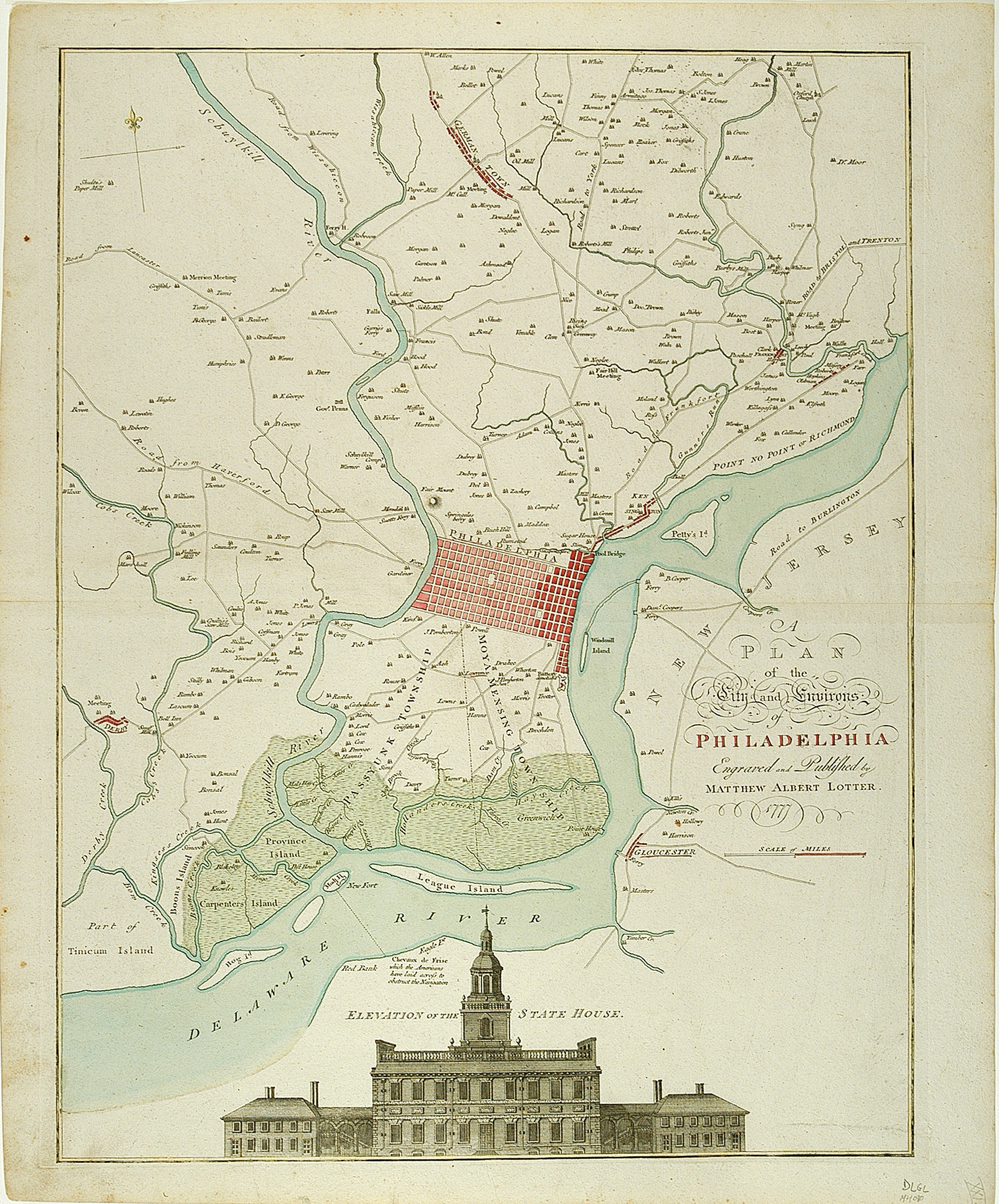
A Plan of the City and Evirons of Philadelphia
Matthaus Albrect Lotter
[Augsburg]: 1777The Society of the Cincinnati, Robert Charles Lawrence Fergusson Collection
Based on the original surveys of Nicholas Scull, a Pennsylvania native, this map details the expansion of the city of Philadelphia along its waterfront and shows the location of navigational barriers installed by the Americans in the Delaware River to obstruct the British. It also features a striking elevation of the State House, where the Declaration of Independence was debated and adopted just the year before. [1999]

Click for a larger view.
A Plan of the Battle, on Bunkers Hill Fought on the 17th of June 1775
London: Printed for R. Sawyer & J. Bennet ..., 1775The Society of the Cincinnati, The Robert Charles Lawrence Fergusson Collection
Issued only a few months after the Battle of Bunker Hill, this map shows the positions and movements of the American and British forces on and around Breed's Hill. A note in teh Charles River just west of Charleston Neck reads, "hither the Ships ought to have come"—a reflection on Gen. Henry Clinton's recommendation to trap the Americans on Charlestown peninsula that was overrruled by Gen. William Howe. [2013]

Click for a larger view.
Plan of the Investment of York and Gloucester
Sebastian Bauman
Philadelphia, 1782The Society of the Cincinnati, The Robert Charles Lawrence Fergusson Collection
Within days of the British surrender at Yorktown, Gen. George Washington directed Maj. Sebastian Bauman of the Second Regiment Continental Artillery to survey the battlefield and encampments. The following year Bauman collaborated with a Philadelphia engraver, Robert Scot, to publish this elegant large-scale map "in order that the public may form an idea of that memorable siege." Dedicated to General Washington, Bauman's plan delineates the topography, fortifications, siege works, positions of the American and British lines, headquarters of the commanding officers and "The Field where the British laid down their Arms." [2015]

Click for a larger view.
Carte de la Partie de la Virgine ou l'Armee Cobinee de France & des Etas-Unis de l'Amerique a Fait Prisonniere l'Armee Anglaise Commandee par Lord Cornwallis le 19 Octobre. 1781
A Paris: Esnauts & Rapilly, [ca. 1782]The Society of the Cincinnati, The Robert Charles Lawrence Fergusson Collection
While most American and British maps of the Yorktown siege focus on the actions in and around Yorktown and Gloucester, this French map pulls back to encompass the Chesapeake Bay region all the way up to the Potomac River. It emphasizes, in dramatic schematic form, the key role of the French navy in sealing off the entrance to the bay, trapping Cornwallis's army on the Yorktown peninsula. IN one of his earliest communications with General Rochambeau, George Washington wrote that "in any operation, and under all circumstances a decisive Naval superiority is to be considered as a fundamental principle, and the basis upon which every hope of success must ultimately depend." This map illustrates the fulfillment—and proof—of that principle. [2017]