Revolutionary War maps range from hasty sketches of roads and paths to elaborate topographical charts depicting elevations, roads, streams and buildings. They were created to support and document military operations as well as to inform the public about the course of the war. These ten reflect the variety of fine maps created during the era of the Revolutionary War and are distinguished for their detail.
By the late eighteenth century, military mapmaking had become a fine art. European military engineers were trained as cartographers, and many used pen, ink and watercolor to produce extraordinary manuscript maps. The maps of British engineer Charles Blaskowitz and French engineer Michel Capitaine du Chesnoy are among the finest military maps ever created.
American engineers generally lacked the training to produce sophisticated maps. As in other aspects of the art of war, they imitated European models and grew more proficient. By the end of the war, Continental Army engineer Sebastian Bauman was able to create a map of the Siege of Yorktown comparable to the best British and French military maps. Immensely proud of his accomplishment, Bauman oversaw the engraving and publication of the map and its distribution to the American and French officers who purchased it. A pristine copy of the the Bauman map is one of the special treasures of the American Revolution Institute.
The maps are listed below in the order they were created. We attribute the maps to the cartographers who created them, rather than to the publishers who printed and distributed them, except for Sayer and Bennett’s simple map of the Battle of Bunker Hill, for which the cartographer is not identified, and Jean Lattré’s 1784 map of the United States, for which the cartographic details were compiled from existing maps. For manuscript maps we indicate the date the maps were drawn. For published maps, we provide the publication date. British map publishers like William Faden sometimes published detailed maps of battles within a few months of the engagements and issued revised versions as new information reached them.
The illustrations below are mostly details, offering important parts of much larger maps. Click on the link at the bottom of each entry to view the whole map in the Institute’s digital library.
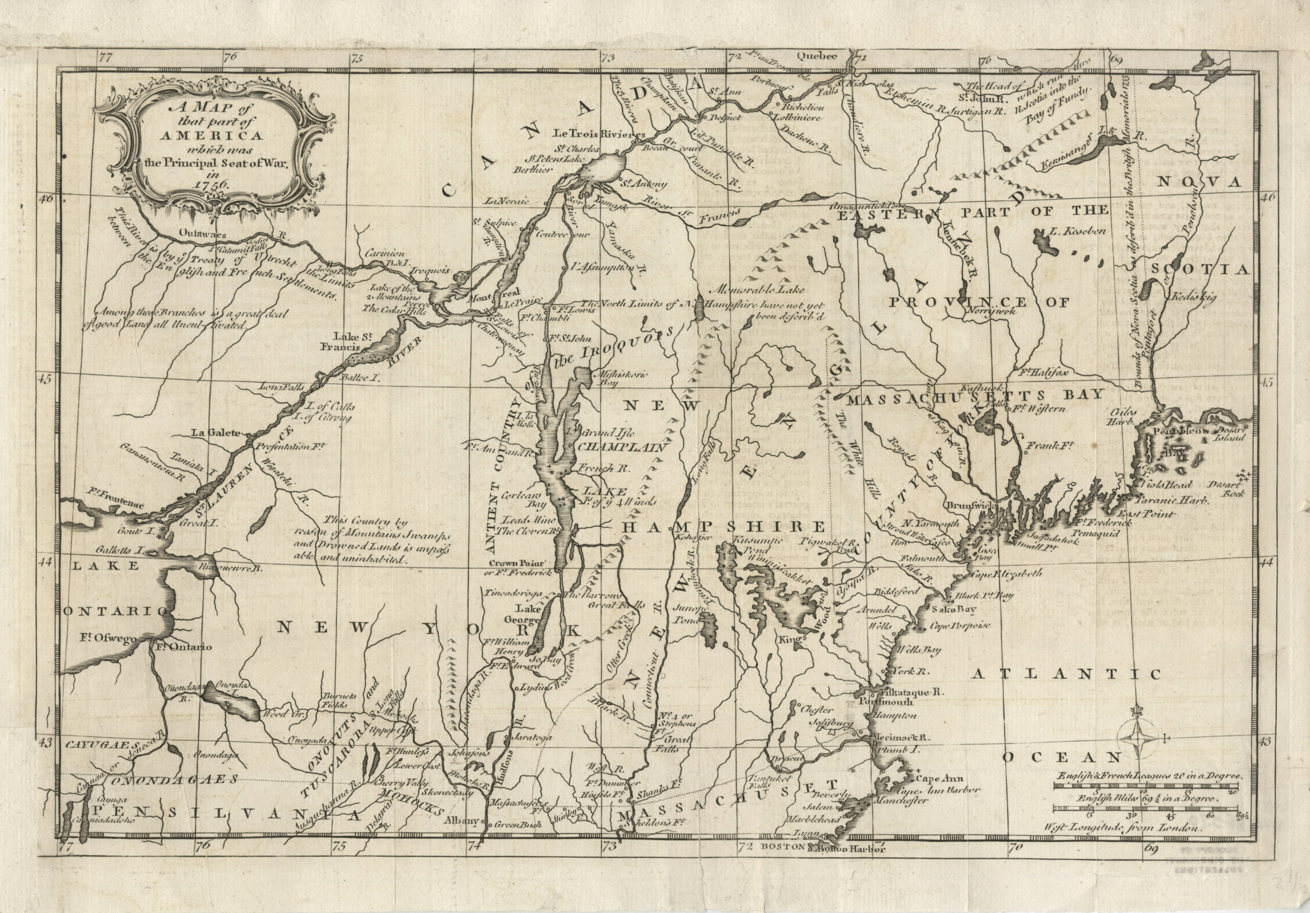
February 1757
A Map of that part of America which was the Principal Seat of War, in 1756
The American Revolution Institute of the Society of the Cincinnati
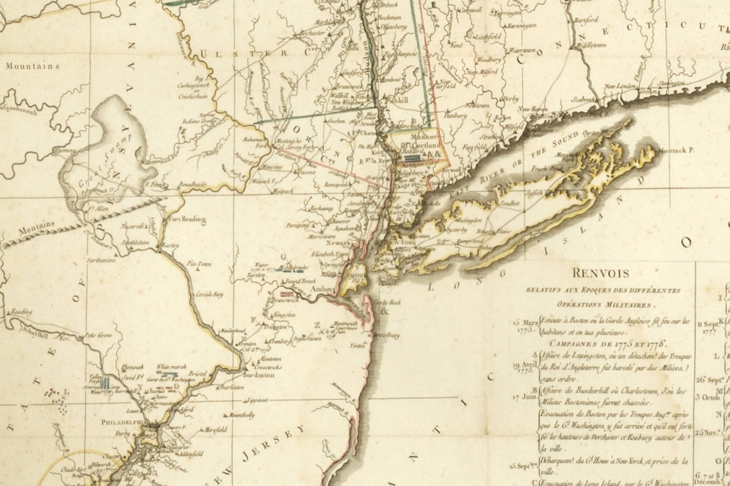
At a time when news from the American colonies traveled slowly, the earliest graphical information available to the British public frequently came from magazines. Published in the Gentleman’s Magazine in London, this map extends from Lake Ontario and Fort Ontario to western Nova Scotia, centered on Lake Champlain and the Iroquois Country. This detailed map of New England and the northern colonies was intended to inform the British public of the regions and progress of the battles being fought during the French and Indian War. The map includes notes on the Treaty of Utrecht and other boundaries, along with the various forts southeast of the St. Lawrence River. The map depicts America prior to the Revolutionary War and before colonial resistance to imperial regulation and taxation moved toward rebellion.
View the Whole Map
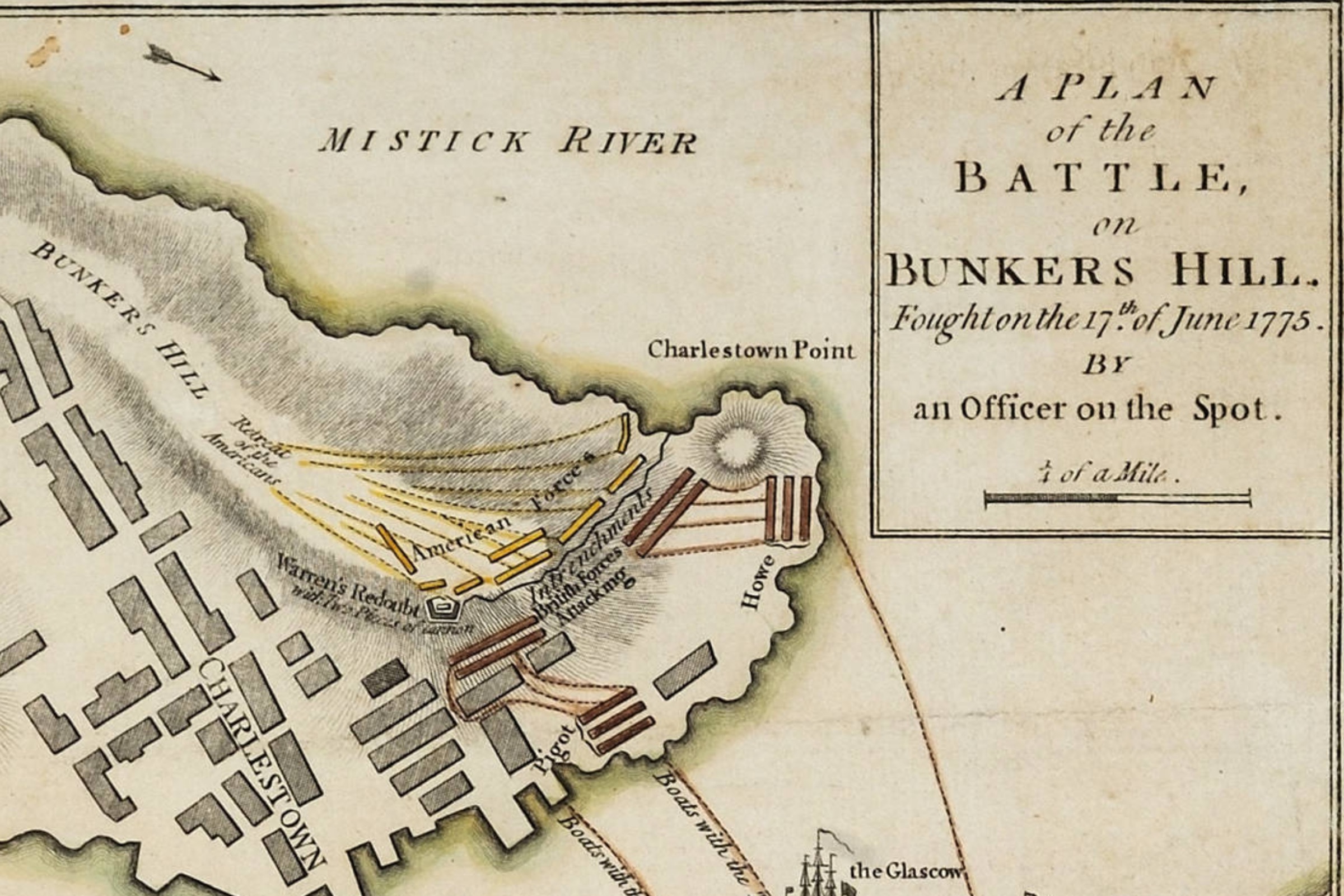
November 1775
Robert Sayer and John Bennett, A Plan of the Battle, on Bunkers Hill
The American Revolution Institute of the Society of the Cincinnati
This is an outstanding example of a map produced for broad public consumption. Sayer and Bennett, who ran one of the largest print and map businesses in London, published this map five months after the Battle of Bunker Hill. Victory there cost the British over one thousand casualties and led to the replacement of the British commander in Boston, Gen. Thomas Gage, with Gen. William Howe. Gage left Boston in October and arrived in London shortly before this map was published. His downfall was the talk of the city. The map occupies two-thirds of the print. The lower third is an eyewitness account of the battle, praising Howe, by Gen. John Burgoyne.
View the Whole Map
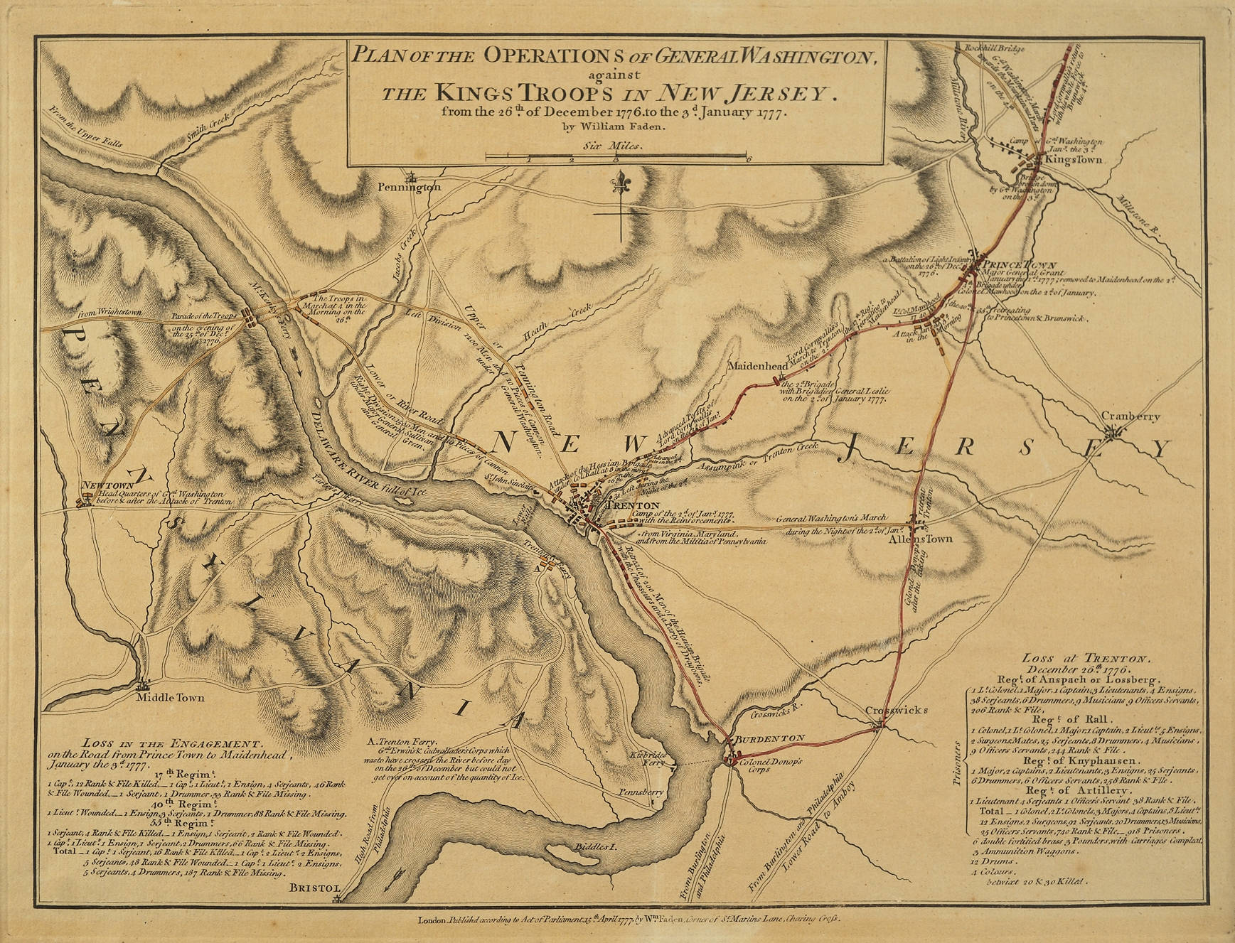
April 1777
William Faden, Plan of the Operations of General Washington, against the Kings Troops in New Jersey
The American Revolution Institute of the Society of the Cincinnati
This map depicts events of the New Jersey campaign from December 26, 1776, to January 3, 1777. The map documents the famous crossing of the Delaware River from Pennsylvania into New Jersey on the night of December 25, led by General George Washington. Washington attacked the Hessian garrison at Trenton at dawn the next day, which resulted in an American victory. This map details the number of British and Hessian losses in the lower left and right columns, along with the routes taken by the American troops to Trenton and the action there.
View the Whole Map
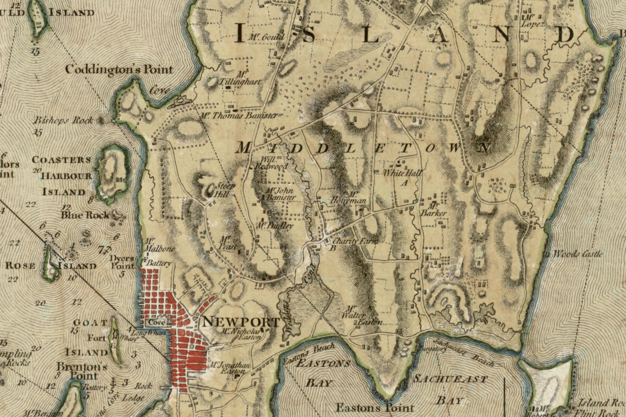
July 1777
Charles Blaskowitz, A Topographical Chart of the Bay of Narraganset in the Province of New England
The American Revolution Institute of the Society of the Cincinnati
As part of a team of British engineers, Charles Blaskowitz surveyed Narragansett Bay in 1764. He returned in 1774 to add the farms and additional features, which made this map one of the most comprehensive British maps of the war, scarcely rivaled for topographical details. The British occupied Newport in December 1776. This version of the map was published by William Faden in London in 1777 and was used by British forces during the Battle of Rhode Island on August 29, 1778. Blaskowitz drew many of the finest British maps of the Revolutionary War.
View the Whole Map
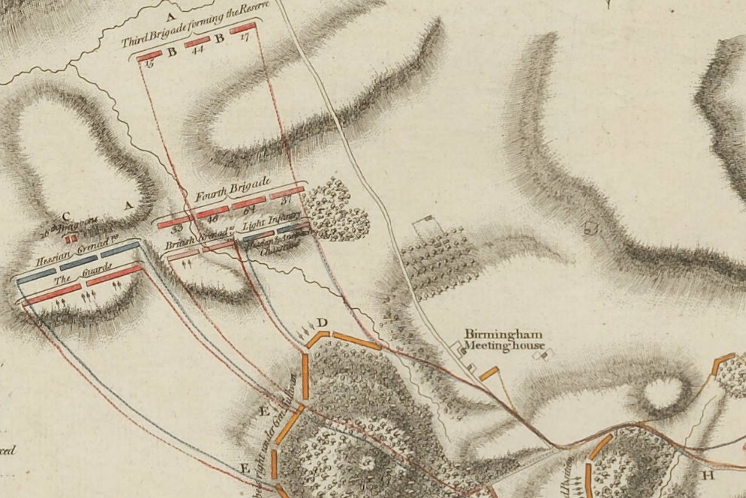
April 1778
Friedrich Wilhelm Werner, Battle of Brandywine in which the Rebels were defeated
The American Revolution Institute of the Society of the Cincinnati
On September 11, 1777, the British Army under General William Howe outflanked Washington’s defensive position on Brandywine Creek in southeast Pennsylvania and defeated the Continental Army in a sprawling, hard-fought battle. Hessian Lt. Friedrich Werner drew a plan of the battle on which the London publisher, William Faden, based this map. Faden, who published detailed, large-format maps of many of the war’s important battles, issued a significantly revised version of this map in 1784, in which “Rebels” in the title is replaced with “Americans.”
View the Whole Map
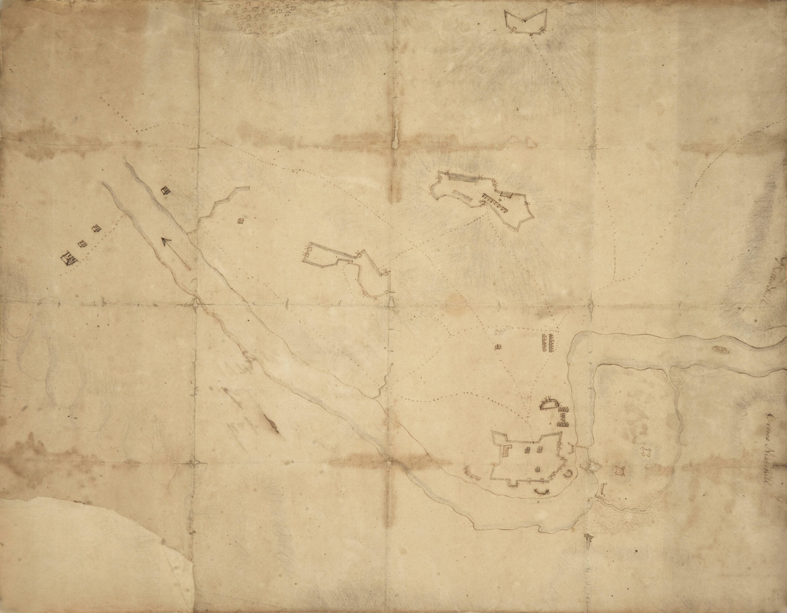
1779
Andrew Engle, Plan of West Point and surroundings
The American Revolution Institute of the Society of the Cincinnati
This ink, pencil and watercolor map depicts the topography and fortifications at West Point, the oldest continuously occupied military post in the United States. The original drawing, attributed to Capt. Andrew Engle of the Twelfth Pennsylvania Regiment, includes signification fortifications of Fort Arnold, later named Fort Clinton, and its outlying redoubts overlooking the S-turn in the Hudson River; Fort Webb and Fort Putnam located downriver; and the fortifications on Constitution Island across the Hudson. The famous chain that stretched across the river to control traffic is also shown. The West Point location was also was used as the temporary headquarters of George Washington from July until November 1779. After the conclusion of the American Revolution, West Point was used as a storage facility for cannon and other military property of the Continental Army.
View the Whole Map
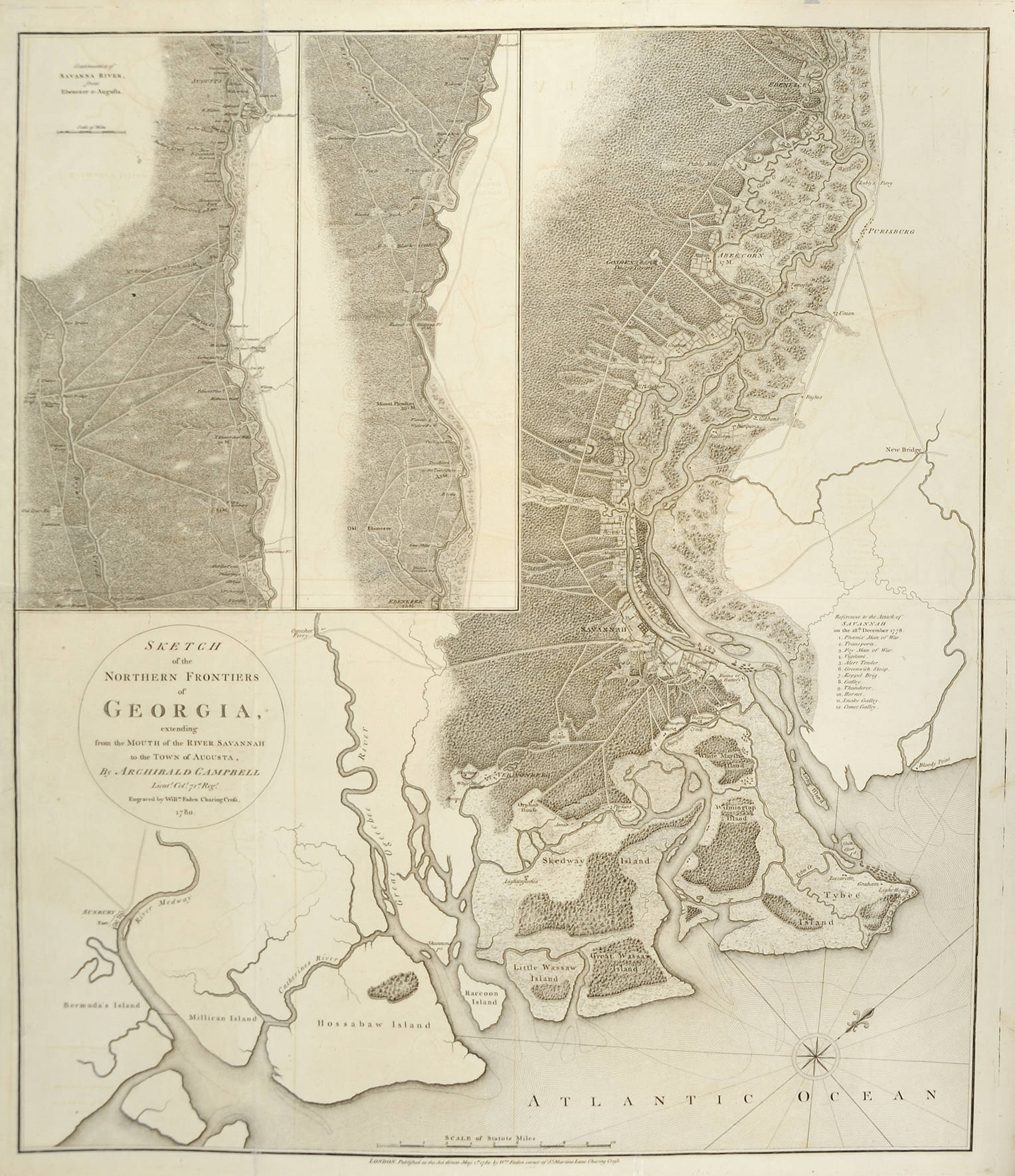
May 1780
Archibald Campbell, Sketch of the Northern Frontiers of Georgia, extending from the Mouth of the River Savannah to the Town of Augusta
The American Revolution Institute of the Society of the Cincinnati
Archibald Campbell’s map of northern Georgia, published by William Faden, depicts the commencement of hostilities in the South by the British Army in December 1778. Campbell had arrived in Georgia with a force of three thousand British troops who quickly seized control of Savannah and Augusta. Campbell’s map drew upon De Brahm’s Map of South Carolina and a Part of Georgia (1757), but with a more detailed depiction of the inland geography and information gathered during the 1778-1779 campaign. The failed French-American Siege of Savannah from September 23 to October 18, 1779, retained British control of the city. During the siege, French admiral Charles Henri d’Estaing was wounded and Casimir Pulaski, the Polish-born commander of the American cavalry, was killed. Nearly one thousand other French and American soldiers were killed, wounded or captured in the attack.
View the Whole Map
1780
Michel Capitaine du Chesnoy, Carte du Théatre de la Guerre dans l’Amérique Septentrionale
The American Revolution Institute of the Society of the Cincinnati
Lafayette instructed his staff cartographer, Michel Capitaine du Chesnoy, to prepare this map depicting the theater of war in the northern states as a tool to help him persuade the French ministry to send an expeditionary force to support Washington’s army. Capitaine compiled the topographical features from other maps and added details documenting the course of the war to date. He accompanied Lafayette to France in 1779, when Lafayette presented a manuscript version to King Louis XVI. The map was engraved under the direction of cartographer Jean-Baptiste Fortin and sold in Paris in 1780, about the time Rochambeau’s army departed for America. Capitaine returned to America with Lafayette and drew some of the finest maps of the Revolutionary War.
View the Whole Map
1782
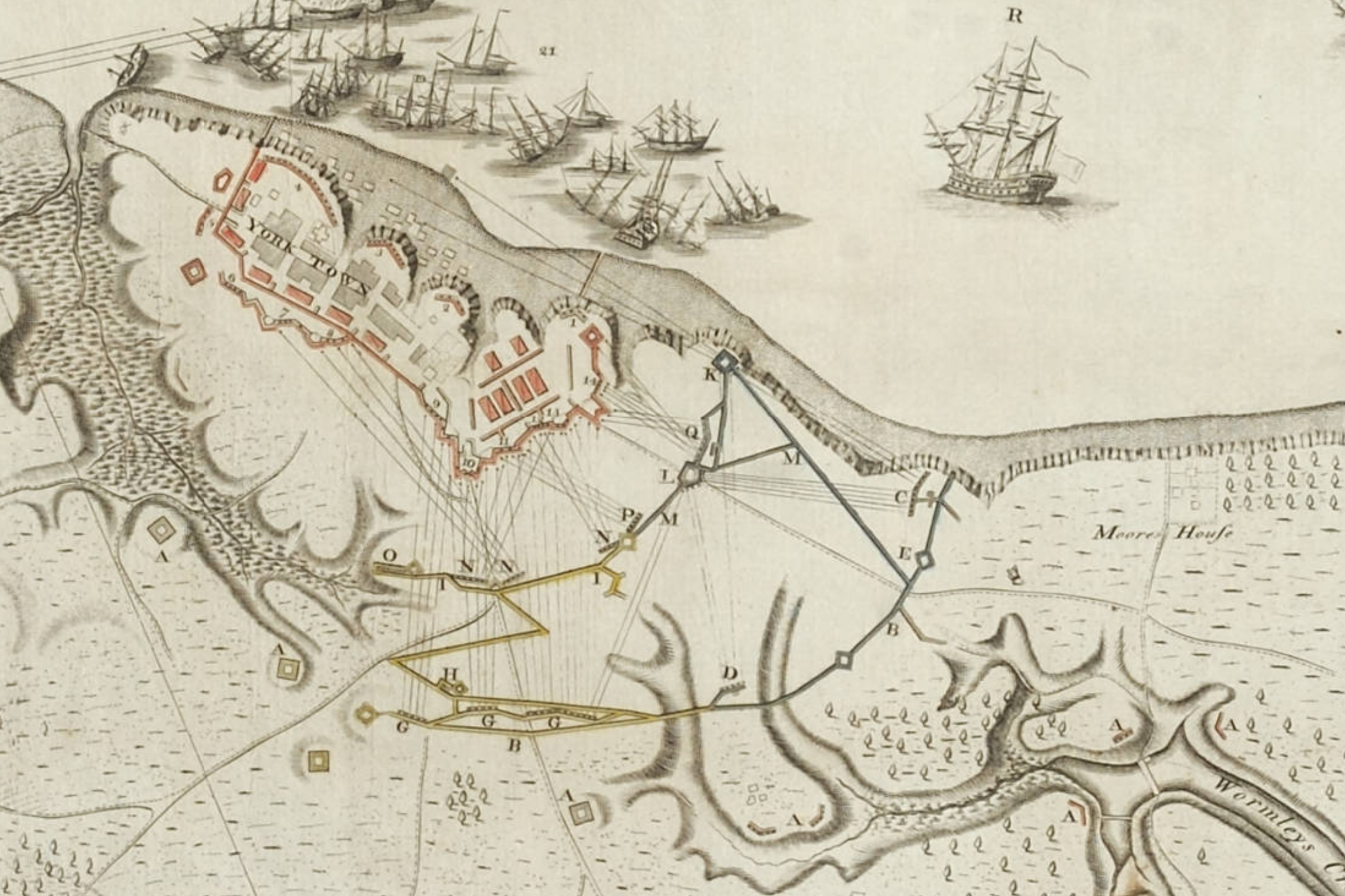
Sebastian Bauman, Plan of the Investment of York and Gloucester
The American Revolution Institute of the Society of the Cincinnati
In the fall of 1781, the combined armies of Washington and the comte de Rochambeau laid siege to the British Army under Charles, Lord Cornwallis, in Yorktown and forced it to surrender. Sebastian Bauman, a Continental Army engineer, surveyed the siege lines immediately after the victory and produced this map, published in Philadelphia in 1782. The finest printed American map of the Revolutionary War, its greatness lies in fine details. In this portion of the map Bauman depicted the fire from the the allied artillery that compelled the British surrender.
View the Whole Map
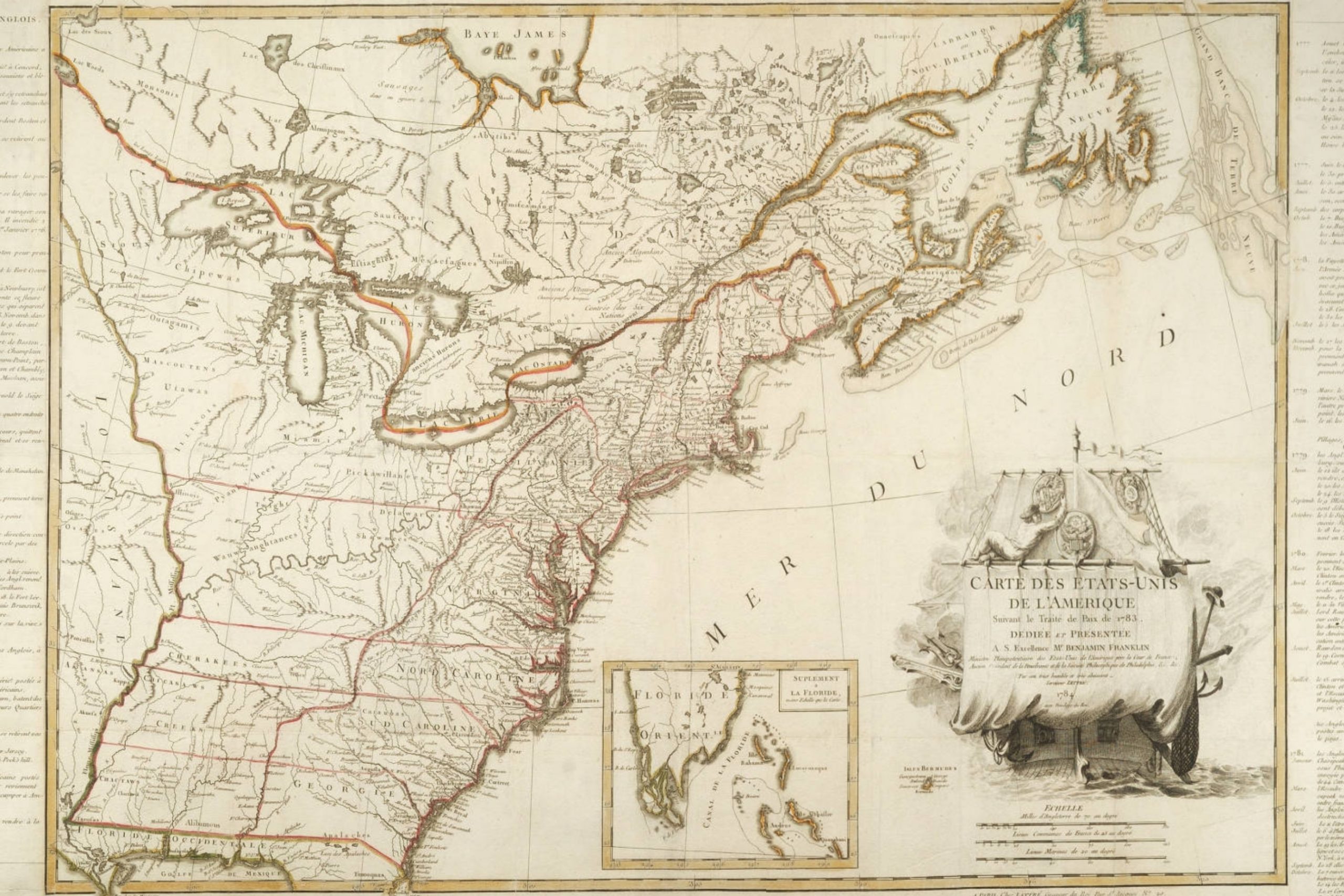
June 1784
Jean Lattré, Carte des Etats-Unis de l'Amerique suivant le Traité de Paix de 1783
The American Revolution Institute of the Society of the Cincinnati
The United States and Great Britain exchanged documents confirming their ratification of the Treaty of Paris in May 1784. The next month Jean Lattré, an official engraver to Louis XVI, published this large-scale map—the first map to delineate the full extent of the new United States of America after the ratification of the treaty. The elaborate cartouche depicts a sailor hanging medallions bearing the Great Seal of the United States, the insignia of the Society of the Cincinnati and the arms of Benjamin Franklin (to whom the map is dedicated) on the highest yard aboard the new ship of state.
View the Whole Map